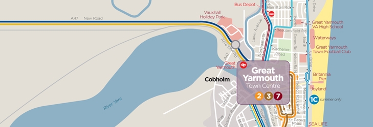
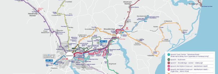
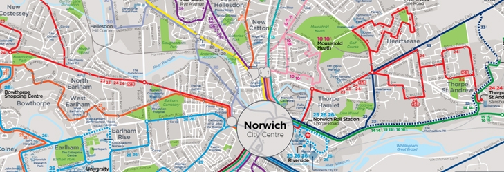
Network Maps
Norfolk & Suffolk - Network Maps
We've made these handy maps to help you find your way around Norfolk & Suffolk with us.
We've made these handy maps to help you find your way around Norfolk & Suffolk with us.

Monday 20th July 2026 to Friday 14th August 2026
Due a road closure we will be unable to serve Ranworth Rd and Mill Rd on the above dates
Please use The Tamarind on Woodbastwick Rd as alternative stop in and out of the City.
Sorry for any inconvenience.
Wednesday 22nd July 2026 to Friday 24th July 2026
Due to a road closure we will be unable to serve Trowse on the above dates.
Buses will divert via A146 turning right into Arminghall Lane to resume normal route to Stoke Holy Cross
Sorry for any inconvenience
Route Diversion, Services 11,11A, 12
Due to a part closure on Wroxham Road Sprowston Park & Ride services will be on diversion heading into the city,
via Atlantic Avenue, Salhouse Rd, Blue Boar Ln, Tesco's, then back onto Wroxham Rd to resume normal route.
services may depart earlier that the stated time, so please allow extra time for your journey.
UPDATED 22nd July 2026
The second phase of works at the Easton roundabout start from 31st July and will continue until the end of the year.
During this phase, we will continue to operate via the existing diversion route on journeys toward Norwich, and will adopt this diversion route for all journeys toward Dereham, King's Lynn and Peterborough.
The temporary stop located just before the junction with Bluebell Way, will be the only stop Excel serves, in both directions, so please signal clearly to the driver to stop.
We remain committed to providing a service up to every 30 minutes for Easton.
UPDATED 29th June 2026
Temporary Changes to Services in Easton
From Wednesday 1st July, Highways England will be partially closing the Easton roundabout. This closure will mean that First Bus Excel services cannot turn right into Easton village.
We are pleased to say that a viable diversion route, using Bluebell Way and Fennel Drive has been assessed, and that Excel journeys toward Norwich will be able to serve the village.
All Norwich bound journeys will exit the A47 at the Longwater junction, then head westbound in to Easton, turning around using the diversion route.
Norfolk County Council are arranging for a temporary stop to be located just before the junction with Bluebell Way. Please note: this will be the only stop that Norwich bound Excel services use. Excel buses heading toward Dereham, King's Lynn and Peterborough will not serve this stop
Journeys from Norwich are unaffected and will continue to serve Easton as normal.